Geomapping technology: unlocking transformational potential
On January 25th, Small Foundation and Palladium launched A Paradigm Shift in Lending to Smallholder Farmers: The Potential of Geomapping Technology. The report explores the potential geomapping technology offers financial intermediaries in expanding access to finance to smallholder farmers.
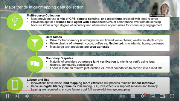
The report identifies trends in the application of geomapping technology, such as the continued requirement to triangulate location information by cross-referencing using multiple data sources, as well as trends in the provision of geomapping services, offering a segmentation of geomapping providers.
Using case studies, the report reflects the range of applications of geomapping technology across the globe. The case studies highlight enterprises using geomapping technology to engage with smallholders directly, like SyeComp and Apollo Agriculture; enterprises that work with agribusinesses, like Koltiva; and those that work directly with financial institutions, like YAPU. Also profiled are companies like CropIn, which uses geomapping to engage across the agricultural ecosystem, and corporate initiatives that feature geomapping technology like Bayer FarmRise.
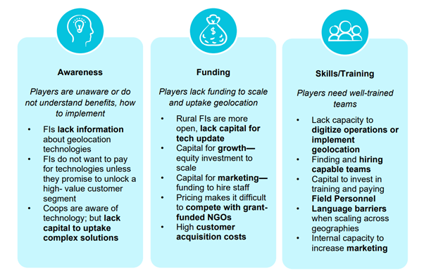
The report additionally identifies barriers to scale for geomapping technology. These barriers, such as challenges with resolution, necessitating the cross-referencing of location information to ensure accuracy, or that data largely remains siloed by value chains, have thus far hindered financial service providers and geomapping technology providers in capitalising on the opportunity to shift the current system and perception of lending to smallholder farmers.

To launch the report, and to stimulate further conversation around this space, Small Foundation hosted a webinar and panel discussion on January 25th. The panel included:
- Erin Leyson, Senior Associate at Palladium, who led the research
- Bruce Cameron, Manager, SME Finance at the US International Development Finance Corporation (DFC)
- Jitesh Shah, Chief Revenue Officer at CropIn
- Oliver Mundy, a geospatial consultant with the International Fund for Agricultural Development

Three key elements stood out from both the research and panel discussion. Firstly, that geomapping technology offers an opportunity to change the current system of extending credit to smallholder farmers. A variety of models are being developed, adapted and scaled to meet the enormous need of both smallholders seeking credit, and that of financial intermediaries seeking to meet the existing smallholder finance gap. The advantage of this proliferation of models is that many geomapping tools offer an opportunity to layer services, such as weather information or agronomic support, on top of the benefits of understanding a farmers’ landholdings and location. This ability to layer is to the benefit of both smallholders and financial institutions.
Secondly, that a critical constraint to growth is lack of awareness of the advancement of geomapping. Though the technology continues to improve, many financial intermediaries lack information on the potential benefits of adoption.
The final element is that the funder community can play an active role in the geomapping technology space, through support to build awareness within financial intermediaries, and by funding initiatives that utilise the technology.
Questions and comments regarding the report are warmly welcomed. Please feel free to contact Thomas Caffrey Osvald: thomascaffreyosvald@smallfoundation.ie
See the initial guest post from Palladium about this research on our blog.

